Invasive Weed Removal Accelerated by Successful Grant Applications

Congratulations to our members for their efforts in securing grants to hasten the removal of weeds that are invading the critically endangered Eastern Suburbs Banksia Scrub. Although our group has been very successful at weed control throughout the years, this will enable us to really blitz crucial areas.

The three successful projects are, in summary, to:

1. Rid the western section near Pioneer Park of a serious infestation of the listed weed Morning Glory and other weeds including turkey rhubarb
2. Remove an extensive invasive section of buffalo grass and other weeds along the southern fire management trail which will also encourage birdlife
3. Weed the narrow north end of MHNP (west) bordered by Commonwealth land which is infested with weeds which are invading the national park.

We thank the Australian Department of Agriculture, Water and the Environment and the Department of Industry, Innovation and Science for their support.

Hunting the Orange Hawkweed – a short story of an adventure in the Snowies.

Tags

, , , , ,

Bruce Alston, who works with the Friends of Malabar Headland bush regeneration group, spent a November week on the National Parks and Wildlife Service (NPWS) orange hawkweed eradication program in the Kosciuszko National Park.

Orange hawkweed (Hieracium aurantiacum) was discovered in Kosciuszko National Park in 2003. Since then, an eradication program has been conducted to avoid widespread infestation and ongoing control costs.

These perennial European weeds damage native ecology by forming dense mats and outcompeting other species. There is also the potential for significant loss of agricultural land if left unchecked. Some 6 million hectares of land has been affected in New Zealand by various species of hawkweed.

The eradication program deploys a core of NPWS officers and volunteers to search out individual infestations of hawkweed in the NSW high country.

Each day, officers and volunteers set off from the NPWS depot in Khancoban for locations in the Jagungal Wilderness area. In these locations, hawkweed has been found and treated to avoid its spread. To ensure every last plant is located, participants walk in staggered lines, within grids defined by handheld GPS devices. The effect is not unlike a police line searching for evidence.

Hawkweed grows in a range of habitats including in tussock and boggy country and on wooded slopes. It can be difficult to spot among a variety of similar looking plants, especially early in the season before it buds. Finds were relatively rare and much celebrated. There is hope that the plant is being held in a ‘deathgrip’ by the team dedicated to its destruction. At a later stage, drones capable of recognising the flowers, and sniffer dogs will also be used to track it down.

Some of the search locations were stunning, with views of Mt Jagungal and the main range. We were blessed with perfect temperatures for high country walking and had only one day with some bushfire smoke. The work can be demanding at times, as each walker must try to hold the line, even when confronted with dense and prickly vegetation or bog. Rather than going around obstacles, the general rule is ‘crash on through’, as hawkweed can be hidden in the scrub or in the wet. There are also copperheads and brown snakes to watch out for.

After work, we swam in the Khancoban pondage and the Swampy Plains River – and enjoyed cold beer and hot meals at the Alpine Inn pub (when not cooking at our comfortable NPSW rental accommodation).      

If you would like to know more about participating as a volunteer in the hawkweed eradication program, please refer to the NPWS website: www.nationalparks.nsw.gov.au/things-to-do/volunteer-activities/hunting-hawkweed.

See also, this item on the ABC’s Gardening Australiahttps://www.abc.net.au/gardening/factsheets/hawkweed-hounds/11709068

Bruce marking a hawkweed find.

WESTERN WALKWAY OPENS IN MALABAR HEADLAND NATIONAL PARK

Here is a story written by our Secretary, Therese Weiss (with input from bush carers of FoMH) about the recent history of the Western Bushland, now the Western Section of Malabar Headland National Park.

MalabarWesternWalkway

The time: mid-1990s. The place: a patch of bush, south of Maroubra Beach, adjoining the Anzac Rifle Range and backing on to suburban housing. Four cul-de-sac streets point their stubby fingers expectantly into the bush. “This is better than the Royal!” I exclaimed to myself as I walked through the heath. There were some tracks worn in various places, punctuated with burnt-out car wrecks. Unfortunately, the land is zoned for housing.

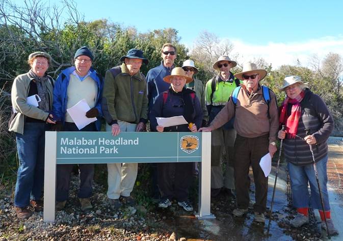
Fast forward to Saturday 17 February, 2018. The Mayor of Randwick, Councillor Lindsay Shurey (long-term member of Friends of Malabar Headland, Greens Councillor) formally opens the walkway in the 17 hectare section of MHNP, known as the Western Section, in the presence of hundreds of local residents. Friends of Malabar Headland have received an official invitation.

What happened in the interim?

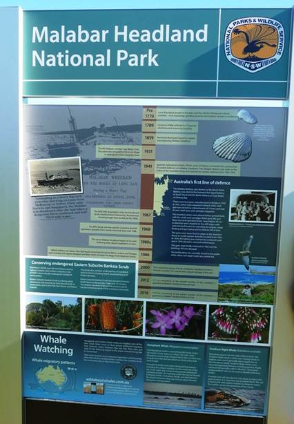
            In August 1987, the Western Bushland was included on the Register of the National Estate by the Australian Heritage Commission.

Car wrecks were removed and fencing put up in 2001, with a fire-break between the fence and the 1960s and 1970s home unit blocks.

FoMH had advocated vigorously over sixteen years to have the bush rezoned as “National Parks and Nature Reserves”, through a campaign of raising local awareness and letter-writing stalls at community events, and promoting the beauty of the bush by giving prizes at two annual local art shows. There were numerous meetings with councillors, state and federal members, and the local Aboriginal Land Council.

It was announced that parts the Western section would be transferred on 28/2/2011 for conservation purposes from Commonwealth to State ownership, under the Environment ministry of Peter Garrett. In March 2011 Councillor Murray Matson, Greens Mayor of Randwick Council applied to rezone Lot 4 DP 809094 on the Malabar Headland from ‘2B (Residential B Zone)’ to the current ‘8 (National Parks Zone)’ as the first stage of the creation of a new national park on the Headland. The Commonwealth then completed remediation of the Western Bushland (principally removal of small pockets of hazardous and general rubbish.) Transfer of the Western Bushland to its new owner the State of New South Wales was made official with a handover ceremony on 2 March 2012. Declaration of the 17.7 hectares of the western section as Malabar Headland National Park was announced in the NSW Government Gazette no. 126 of 7 December 2012.

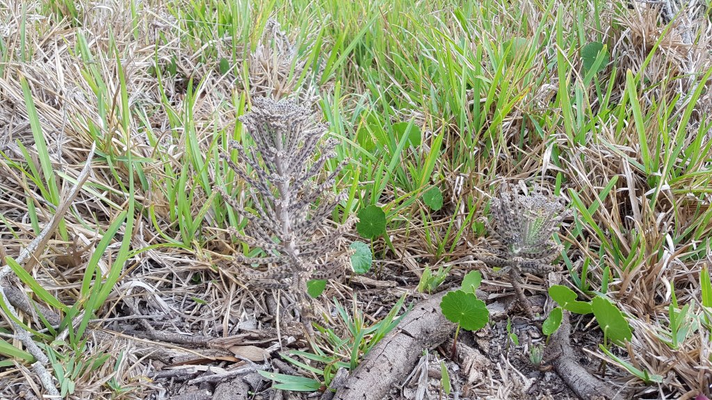
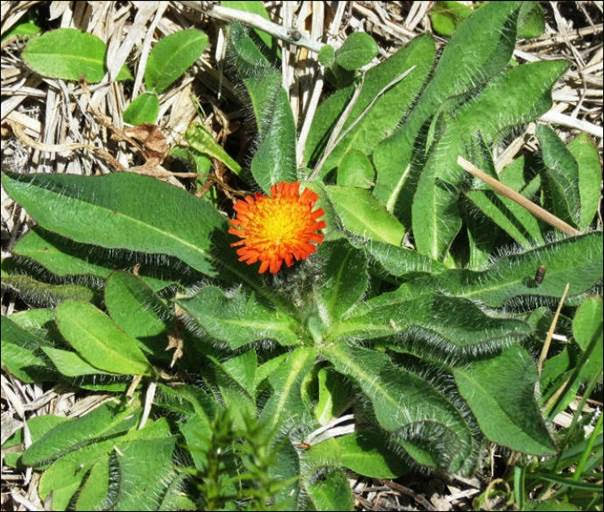
Malabar Headland National Park contains some of the last stands of a relic of vegetation once found throughout coastal areas of Sydney: Eastern Suburbs Banksia Scrub. ESBS in the Sydney Basin Bioregion has been determined to be a Critically Endangered Ecological Community by the NSW Threatened Species Scientific Committee and the final listing was published on 1 December 2017. The 17.7 ha in the western Section includes 5.5 ha of ESBS.

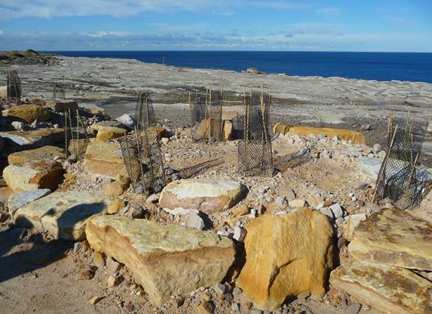
Since 1986 community members (later formed into an incorporated association “Friends of Malabar Headland” in 2000) worked hard and long to remove extensive infestations of bitou, pampas grass and lantana, as well as many other weeds, from the eastern, coastal section of the future park, surrounding the ANZAC rifle range. Alan Hall supervised volunteer bush care in the West since 1996. Some work was also done by contractors on the eastern edge of the Western section. The main infestations were cleared by 2004.  Initially they worked with the permission of the owners, the Commonwealth of Australia.  A new group took over in the West on Sundays from November 2010. Since it became a National Park this group has worked under a Memorandum of Understanding with NPWS. Both East and West groups are still active.

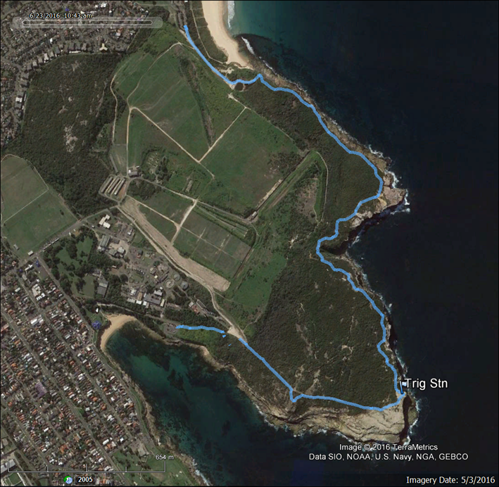
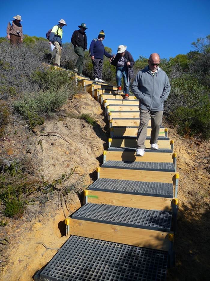
Randwick Council carried out community consultation for the walkway through the western bush in March 2016, and resolved in May 2016 to go ahead with the construction in cooperation with NPWS. The funding was $800,000 from the capital works budget and $200,000 from the Metropolitan Greenspace grant in December 2014.

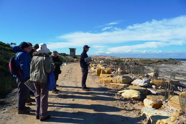
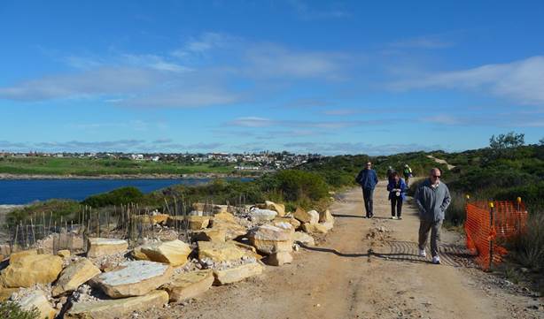
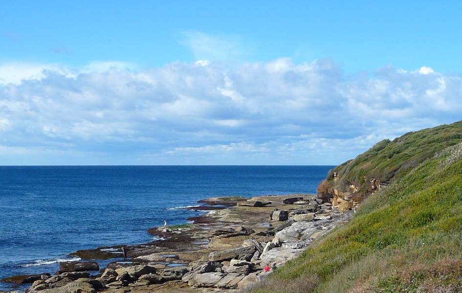
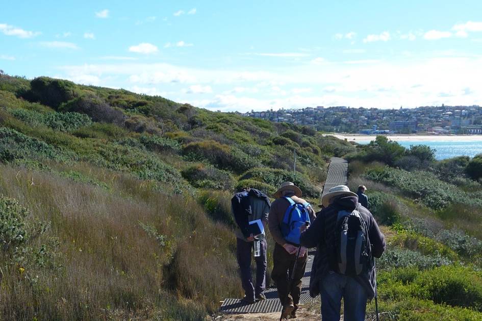
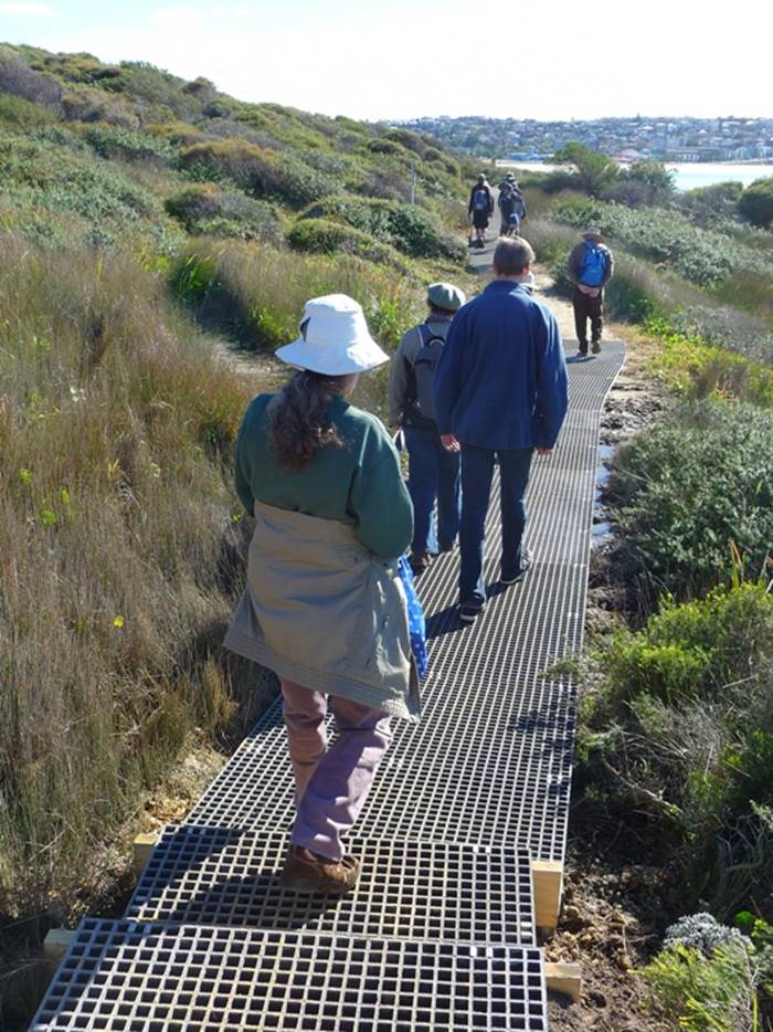
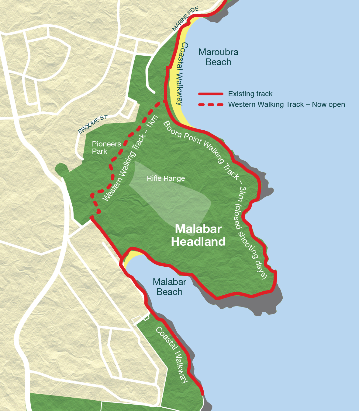
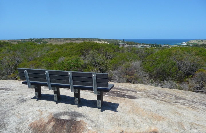
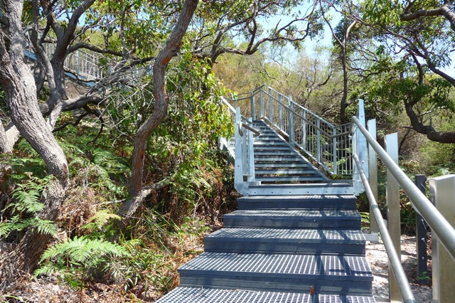
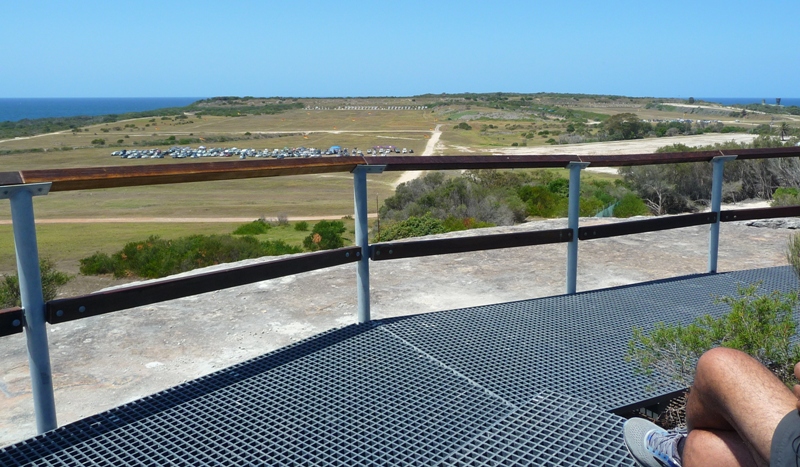
The 1.15 km walkway forms a missing link in the coastal walk which can be used instead of the of the longer 4km coastal track from South Maroubra to Malabar (Long Bay) which is closed to the public when the rifle range is in use on Saturdays, third Sunday of each month, and various weekdays. The walkway, largely a grid-style boardwalk, makes a path up and down through remarkably lovely coastal heath and woodland. The high part on the escarpment overlooks the rifle range for a splendid view of the ocean.

FoMH will continue to work to help the community to meet the challenge of caring for high quality bush so close to suburbia. The park survived informal use over many years. Ongoing problems include littering, dumping, campfires, dogs, and tramping off the tracks. We hope that with increased formal use and popularity, everyone will act in a friendly manner towards Malabar Headland.

P1210255 seat overlooking STP

P1210217 stairs, bottom of escarpment

P1210225 view from escarpment seat

References:

http://www.yoursayrandwick.com.au/malabarwalkway viewed 13 February 2018

https://www.randwick.nsw.gov.au/planning-and-building/council-works-and-upgrades/major-projects/coastal-walkway-works viewed 13 February 2018

https://malabarheadland.org.au/

http://leptracking.planning.nsw.gov.au/proposaldetails.php?rid=406

http://www.environment.nsw.gov.au/resources/threatenedspecies/determinations/FDESBSCEEC.pdf

https://www.nationalparks.nsw.gov.au/visit-a-park/parks/malabar-headland-national-park/local-alerts

Photos supplied by Claire Bettington, FoMH

Map supplied by Randwick Council.


NSW NPWS Malabar Headland National Park website

Now that the MHNP (Eastern section) is officially open, NPWS has established a website for the new National Park.

The website can be accessed here.

There is another link to the NSW NPWS Malabar Headland NP site in the ‘Relevant Links” section below left.

Please note that the National Park is closed on days when shooting is underway.

Matt Thistlethwaite MP – Speech in Federal Parliament re Malabar Headland

This speech was made on 18 October 2016 by Kingsford Smith MP (and volunteer Bush Regenerator at MH) Matt Thistlethwaite regarding Malabar Headland and the sneaky 50 year lease of the rifle range:

In May this year the Turnbull coalition government stitched up a secret, dirty backroom deal to lock the community that I represent out of 177 hectares of historically and environmentally significant green space at Malabar headland. Made in the shadows with the crossbench senator and gun enthusiast David Leyonhjelm, the agreement to lease out the central portion of Malabar headland to the New South Wales Rifle Association for the next 50 years has been met with anger, frustration and disbelief in our community.

I have nothing against the New South Wales Rifle Association or any of its members. In fact, they have invited me to some of their events and functions. They are good people and they are dedicated to their sport. But there are now many young families, elderly people and a large number of residents living in the vicinity of Malabar headland, and shooting is no longer consistent with the family environment that lives on the back door of where these shooting activities are taking place.

Having grown up in Maroubra, I have a deep appreciation for the headland and the place that it holds in the hearts of residents, who overwhelmingly want to see the government do what has been promised and find an alternative site for the shooters so that the beautiful and unique headland can be protected from development and returned to the people as public open space.

This is the last remaining tract of native bushland that exists in Sydney between the harbour and Botany Bay. Every other spare spot of native bushland along that coastline has been developed. We must preserve and maintain this historic green space for use and enjoyment by the people of Australia. The former Labor government commenced work to see this goal achieved to preserve the headland. The western portion of the headland was cleaned up at a cost of $2 million and handed back to the New South Wales government to be made a national park. The eastern portion near the ocean was remediated at a cost of $9 million and is now a national park. The central portion requires much more work, given that it was a former waste dump site. Independent reports indicate asbestos and leachate contamination.

Under the coalition government, however, progress towards returning this headland to the people has been slow and is now going backwards. In January this year, it was revealed that the government had commissioned a secret report into development options for the headland, which said that the headland was ‘surplus to requirements’ and would generate ‘significant returns if sold’. Upon release of the report, the member for Maroubra, Michael Daley, and I, with the Friends of Malabar Headland, strongly campaigned against any development on the headland, and, in one day, the environment minister at the time, Greg Hunt, backed down and now claims there will be no such development.

The coalition government had promised at the 2013 election to return the horse riding school that was on the headland back to the headland within six months. It is now over three years and not one horse has returned to the headland. Now the coalition government appears intent on delaying the relocation of the shooters, with Mr Hunt declaring in January this year that they had a ‘long-term future’ on Malabar Headland and that finding the shooters an alternative range could take ‘three, five or 17 years’. The shooting club must be relocated to an alternative premises. Meanwhile, residents are facing an increase in the frequency of shooting activities on the site. The rifle association has been offered a paltry $25,000 per year to lease the site and gain restricted access. The number of days of shooting has increased. Locals have been locked out by security guards from entering the site. We have a national park that no-one can go into on the days that the shooting is occurring because it is a safety risk.

The situation is a direct result of the Turnbull government’s tenuous hold on power, which has led to this joke of a deal being done with Senator Leyonhjelm. It completely ignores the wishes of the community that I represent and locks them out of the headland for 50 years. The government needs to get its act together. It needs to find an alternative site for the shooting club, bring the horses back and provide the local community with safe access to the national park and this headland treasure. It is Labor’s plan to turn this area into a parkland that is open to the people and a national park with walking tracks on the headland. We demand to know when the government will end this farce.

The new Eastern Walking Track in Malabar Headland National Park

Here is a great story on the new Eastern Walkway in MHNP. Photos and words (slightly edited) are by Claire Bettington, Treasurer of FoMH. Great work Claire!


On 4 July, the FoMH committee, some Members of Maroubra Beach Precinct Committee, and staff from Randwick Council walked along the proposed formal track in the Eastern Section, guided by Chad Weston from NPWS.

Please note: the Park is not open to the public yet, there are still muddy sections that need stairs and boardwalk, and workmen are on site. No one is permitted in the Eastern Section on shooting days.

I recorded the walk on my GPS, and have superimposed it on Google Earth imagery:

FoMH1-0716

We started at the Long Bay boat ramp car park, and admired the brand new National Park signs:

FoMH2-0716

FOMH12-0716

And posed for a FoMH group photo at the new entrance sign:

FoMH3-0716

We followed the main track (some of you know this as “Mission Impossible Drive”) to Boora Pt.

There will be an alternative route from the car park, which follows the coastal track half way to Boora Pt, then ascends the spur to a lookout area on the bare rocks on top, close to where the windmill plinth was, now gone.

At Boora Pt, there is a bit of new landscaping:

FOMH13-0716

FOMH14-0716

FoMH4-0716

And the Boora Pt Trig Station has been freshly painted:

FoMH5-0716

Some paths have been blocked off where there are dangerous cliffs or other management issues, but marker signs have been installed, clearly showing direction and distance:

FoMH6-0716

At the erosion gully near Magic Pt, some steps have been installed shown here with Chad, our NPWS Ranger.

FoMH7-0716

Same steps, view from the bottom of the erosion gully:

FoMH8-0716

On the path to Magic Pt, rock fishermen on the wave-cut rock platforms:

FoMH9-0716

On the path from Magic Pt, new boardwalk at the Themeda patch, Maroubra Beach in the distance:

FoMH10-0716

Boardwalk over the mud saves the vegetation from trampling:

FoMH11-0716

More boardwalk is being installed, and the Rifle Range is going to have a secure fence around it to stop people entering it when shooting is happening.

We will keep you up to date with the progress of the boardwalks and more.

The Park should be officially open soon, so watch this space!

Shooters’ 50 year lease of Malabar Headland – a secret backroom deal

We at FoMH feel that the new 50 year lease arrangement is a secret backroom deal which was unannounced (except by Senator Leyonhjelm on Facebook), undiscussed and decidedly underhanded. There was no consultation at all. Just a few months ago we had the shooters and Minister Hunt in agreement that the rifle range would be relocated to another facility in “3, 5 or even 17 years”, and now NSWRA have a new confidential 50 year lease signed sealed and delivered.

It seems that there will be a massive increase in shooting days from the current one or two days per week to 5 days per week. This would mean that the new Eastern National Park would only be open to the public on two days per week, and perhaps not at all on weekends. We think this is an unacceptable situation that could have been avoided if consultation had occurred between ALL the stakeholders of Malabar Headland prior to signing any new lease. This is public land after all.

FoMH was not consulted or notified of the new lease. NPWS were also not consulted and had to confront the NSWRA in a meeting about the news! Local residents were not consulted about the increased shooting days.

FoMH has always recognised that without the Rifle Range, there would probably be no bush now to protect, and we do not view the new 50 year lease as a negative in regard to the protection of the precious ESBS bush. The continued presence of shooters should mean that there can be no development on the headland, although we don’t know the terms and conditions of the lease. We do know that our vision for the whole of Malabar Headland is now many more years away.

It is disappointing that the landfill will not be remediated any time soon, and that the Rifle Range will not become Public Open Space in the near future, but we appreciate that fixing the landfill is a very expensive proposition for any government and we wonder why/how shooters and horses/riders can utilise the unremediated landfill areas safely.

People are quite rightly upset about the complete lack of community consultation in this new lease arrangement and the secrecy associated with the terms of the lease, and how things have changed so quickly from the earlier statements of Minister Hunt. They are confused about how a new National Park can be closed 5 days a week and on weekends. They are worried about noise from increased shooting.

We trust that NPWS and the shooters will work closely together to ensure that there is a satisfactory compromise between public access and shooting access. We understand that if the shooters are not active on any particular day, the Eastern walkway will be accessible, and NPWS will leave the gates in the new fence open at all times EXCEPT when they are shooting. The eastern walkway is progressing at a fast pace, and will be opened very soon. We are hoping for an invite to the opening.

We will be working hard to ensure fair public access to the Eastern walkway and National Park! Why not join us?


Update on what’s happening on the Headland

There are a lot of things happening on the Headland at the moment. There is the construction of Eastern and Western walking tracks, plus fencing, signage and various civil works. Here is a great summary of the happenings from Claire.  Also included is Rifle Range operation dates for the next few months.

MHNP Works update

Eastern Walking Track Work

26 April – TBC Mid to Late June

A crew of 4 will be working from the 26th of April to mid-late June. Installing 350mtrs of temporary elevated mesh boardwalk in wet areas along the main coastal track. Work continues on the detailed design of this route and is scheduled to be completed this financial year.

Civil Works (East)

2 May – TBC 16-23 May

Repair of Access Road / Interim walking track. 2 stages, removal of bitumen and blue metal, replacement with VENM crushed sandstone. Future works will include hardened drainage elements and extending the road to Fisherman’s Rd Carpark (subject to approvals). The access road is for maintenance not public vehicle access.


Park Signage Installation (East & West)

TBC Mid May for 1 week

Installation of safety signage, way finding, park entry & ID signs, closed areas


DoF Fencing Works (East and West)

TBC May – TBC June

Fence installation to reduce informal access and ensure safety of park visitors, will be constructed on DoF land. DoF has indicated a desire to begin these works in May. Awaiting confirmation.


Heritage Structure Security/Stabilisation, Gate Installation (East)

TBC Late May to Mid June

Closure of southern searchlight block and 2 x engine rooms, stabilisation of southern searchlight block pending further assessment. Installation of vehicle gate and bollards at apex of access road to reduce motorbike and pedestrian access to observation tower and gun emplacements.


Bush Regeneration Contractors

14 April – 31 May

4 contractor crews will continue to work sporadically throughout April and May.


Storm Water Remediation (West)

11 April – TBC 22 April

Council have removed the damaged fence at Franklin St / Pioneer Park, they will remove the headwall in the coming days and backfill erosion with VENM crushed sandstone.


Western Walking Track

TBC

Community consultation phase completed (March 31). Randwick Council has indicated a desire to proceed to tender on completion, awaiting confirmation.


NPWS Field Staff

Ongoing

There will be an increase in field staff operations, some of the works we will be doing in-house include; removal of commonwealth signage, repairing heritage structure security, cleaning up the railway line, weed suppression, pest species surveys, closure of informal tracks, etc.


Scheduled Rifle Range Operation Dates

Latest shooting range operation dates below as of 13/4: (may be subject to change)

16th May; 23rd May; 20th June; 11th to 16th July


Annual All Park Passes for Volunteers

Do you need encouragement to participate in bush regeneneration/bush care? For info about working in Botany Bay NP, contact NPWS directly. For info about working in Malabar Headland, see our Membership – Contacts tab.

Volunteers who have completed over 50 hours voluntary service in any one year on an NPWS approved program can receive one free All Parks Pass for one designated vehicle registered at the volunteer’s home address.

Now there is even more incentive to become a bush regenerator with us!


Half of Malabar Headland now safe from development

Friends of Malabar Headland (FoMH) welcomes the handover of the 70 hectare eastern section of the Headland to the state government for the creation of the second part of the Malabar Headland National Park. Our dream for the creation of national parks in the eastern and Western sections of the Headland is about to be realised, and for that we are very grateful. The total park will be 87 hectares, almost exactly half of the total headland.

We look forward to the park being opened to the public in June as proposed by the state government.

However there are many issues to be solved between now and then, especially considering that the park can only be accessed by the public on days when the rifle range is not operating. Issues such as security of the site on shooting days and more secure fencing will need to be addressed.

This will certainly be a unique National Park, not just because of its incredible location, flora/fauna and history, but also because the rifle range has the right to operate 7 days per week if it wishes, which would mean no public access at all in the eastern section!

Presently, the rifle range only operates on Saturdays, but the shooters have indicated that they would like to operate more days per week, with Sunday the preferred day. This would mean no weekend access for the general public.

FoMH have always understood and acknowledged that the existence of the rifle range has enabled the headland to be retained in public hands and, with the help of FoMH bush regenerators, preserved the remnant Eastern Suburbs Banksia Scrub on the site, and most importantly, not lost the headland to development. We hope that the shooters will work closely with National Parks & Wildlife Service to ensure that public access to the park can be maximised. In that way the park and the rifle range can peacefully co-exist until a new home can be found for the rifle range. This could take up to 17 years according to Federal Environment Minister Greg Hunt.

FoMH are still very concerned about the long term future of the remaining 87 hectares of the headland after the shooters relocate, despite Minister Hunt’s claim last year that the “whole site, all of it, will be retained in public hands forever”. Remember, even Barrangaroo is still in public hands.

All levels of government are facing huge fiscal challenges, and privatisation of public assets is one way to plug the fiscal holes in their budgets. The federal government even offers monetary incentives to the states to privatise public assets in their euphemistically titled Asset Recycling Program. The federal government has already looked into development options, and the rifle range site is estimated to be worth some billions of dollars. Cash strapped governments of all persuasions may be tempted to recycle this asset.

FoMHs vision for the other half of Malabar Headland after the shooters relocate, has always been to keep it as public open space, to be used by a large number of groups including horse riding clubs, model airplane clubs and the general public for active and passive recreation.

Our dream of the Malabar Headland National Park is near to fruition, but FoMH will continue to work towards our ultimate dream of saving the entire Malabar Headland for public recreation. As population densities in Sydney increases, the need for this open space also increases. Once it is developed it will be lost forever.

Please join us and help us achieve this dream.

Alison Road tree destruction and Public Land grab – wider implications

Dave Pyett, Chair of Friends of Malabar Headland (FoMH), has issued a media release about the destruction of a whole avenue of mature trees along Alison Rd, Centennial Park, the Public Land grab that allowed the destruction of the trees, and the wider implications of this activity for special places like Malabar Headland.

My name is David Pyett, I am the Chair of Friends of Malabar Headland.

Last Friday and Saturday 48 mature, large, heritage and other trees growing along Alison Rd Randwick were destroyed by the Baird Government, for development of the Light Rail and a station for the Race Course on what was formerly Public Land on the Southern edge of Centennial Park.

The shady bike path along the Alison Road boundary of Centennial Park, taken from corner of Alison and Darley Roads, Friday 8th January 2016. © Claire Bettington

The shady bike path along the Alison Road boundary of Centennial Park, taken from corner of Alison and Darley Roads, Friday 8th January 2016. © Claire Bettington

The trees were destroyed in a lightning fast operation which went on day and night over a 48 hr period.

Same viewpoint, Monday 11 January 2016. Trees pulped and chips spread on ground,  Of 50 trees marked for destruction, only the two Hills Weeping Figs on the right remain (for now) because they were further set back from the road.  © Claire Bettington

Same viewpoint, Monday 11 January 2016. Trees pulped and chips spread on ground. Of 50 trees marked for destruction, only the two Hills Weeping Figs on the right remain (for now) because they were set back further from the road. © Claire Bettington

This morning (Monday 11 January) I attended a “funeral for the trees” at the intersection of Alison Road and Darley Road, with Randwick resident, FoMH member and protester Claire Bettington, and Randwick City Councillor Murray Matson.

Whilst it is too late to save the trees and the land, it is not too late to warn people that the Baird Government has:

(1) Taken Public Open Space land for this section of the Light Rail and the Race Course Station, with no plausible logic, when a better alternative was obvious and already agreed to;

(2) Destroyed dozens of our living heritage trees, again with no plausible logic, when a better alternative was obvious and already agreed to;

(3) Changed the agreed to plans by a substantial amendment, exhibited just before Christmas 2014, a time of the year when hardly anyone was aware or available to comment.

I regard this as a manipulation of the Planning Laws and processes so that environmental and social concerns can be ignored, Public Land can be taken at will for any purpose the government deems fit and awarded to those in the private sector who may or may not be financial donors to the Liberal Party.

The message for us is clear: if the Baird Government can do this quite blatantly to the residents of Sydney and Randwick, then they can do it to Malabar Headland!

The implications for the impending handover to the State Government of the Eastern Section of bush on Malabar Headland are enormous, and if we are not careful, there will be no guarantee of the same protection for the Eastern Section as there is for the Western Section, now a National Park.

We remain ever vigilant for the future of Malabar Headland.

Kind regards

Dave Pyett
Chair, Friends of Malabar Headland
Mob: 0419 498 378

Please feel free to circulate, quote from and publish this media release in whole or part

Dear All

A film maker came along to the tree battleground on Alison Road and documented the efforts of protestors to stop the carnage – watch “Chainsaw Mike” on YouTube

Less than 48 hrs later, 48 trees had been reduced to woodchips, for no reason at all. Only two trees survived. The Light Rail should have been built on the Randwick racecourse side of Alison Road, as originally agreed.

Please share widely, and let Premier “Chainsaw Mike” Baird and Minister for Transport Andrew Constance know how you feel about the destruction.

These were our trees on our Public Land.

With thanks,

Claire Bettington