• Home
  • About Friends of Malabar Headland
  • About the Headland
  • Malabar Battery
  • Eastern & Western Bushland
  • Eastern Bushland
  • Western Bushland
  • Future of the headland
  • Membership – Contacts

Friends of Malabar Headland

~ FoMH

Friends of Malabar Headland

Monthly Archives: July 2016

The new Eastern Walking Track in Malabar Headland National Park

18 Monday Jul 2016

Posted by tdaunt12 in Uncategorized

≈ 1 Comment

Here is a great story on the new Eastern Walkway in MHNP. Photos and words (slightly edited) are by Claire Bettington, Treasurer of FoMH. Great work Claire!


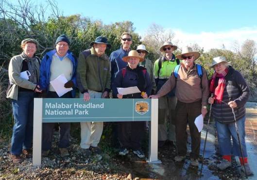
On 4 July, the FoMH committee, some Members of Maroubra Beach Precinct Committee, and staff from Randwick Council walked along the proposed formal track in the Eastern Section, guided by Chad Weston from NPWS.

Please note: the Park is not open to the public yet, there are still muddy sections that need stairs and boardwalk, and workmen are on site. No one is permitted in the Eastern Section on shooting days.

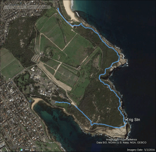
I recorded the walk on my GPS, and have superimposed it on Google Earth imagery:

FoMH1-0716

We started at the Long Bay boat ramp car park, and admired the brand new National Park signs:

FoMH2-0716

FOMH12-0716

And posed for a FoMH group photo at the new entrance sign:

FoMH3-0716

We followed the main track (some of you know this as “Mission Impossible Drive”) to Boora Pt.

There will be an alternative route from the car park, which follows the coastal track half way to Boora Pt, then ascends the spur to a lookout area on the bare rocks on top, close to where the windmill plinth was, now gone.

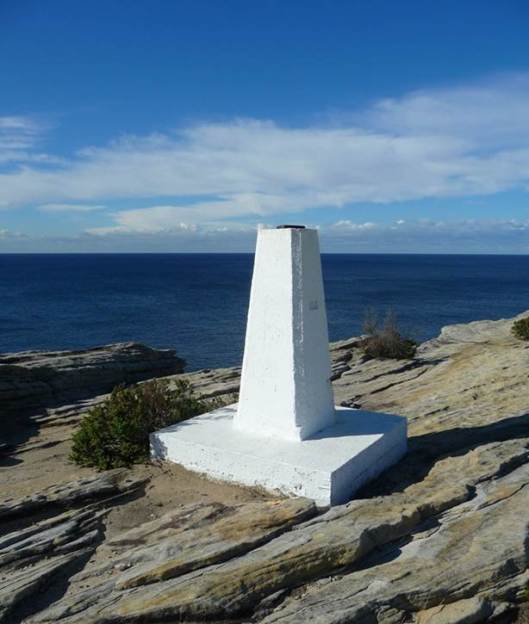
At Boora Pt, there is a bit of new landscaping:

FOMH13-0716

FOMH14-0716

FoMH4-0716

And the Boora Pt Trig Station has been freshly painted:

FoMH5-0716

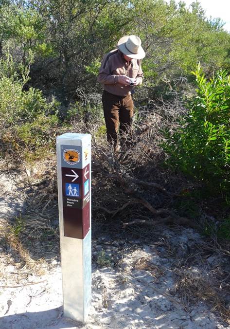
Some paths have been blocked off where there are dangerous cliffs or other management issues, but marker signs have been installed, clearly showing direction and distance:

FoMH6-0716

At the erosion gully near Magic Pt, some steps have been installed shown here with Chad, our NPWS Ranger.

FoMH7-0716

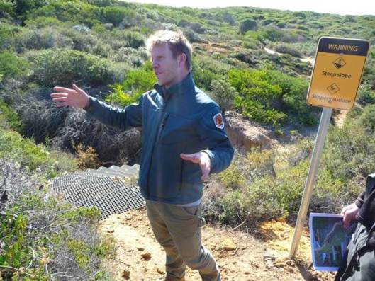
Same steps, view from the bottom of the erosion gully:

FoMH8-0716

On the path to Magic Pt, rock fishermen on the wave-cut rock platforms:

FoMH9-0716

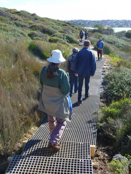
On the path from Magic Pt, new boardwalk at the Themeda patch, Maroubra Beach in the distance:

FoMH10-0716

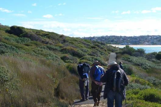
Boardwalk over the mud saves the vegetation from trampling:

FoMH11-0716

More boardwalk is being installed, and the Rifle Range is going to have a secure fence around it to stop people entering it when shooting is happening.

We will keep you up to date with the progress of the boardwalks and more.

The Park should be officially open soon, so watch this space!

Advertisement

Share this:

  • Twitter
  • Facebook
  • Email

Like this:

Like Loading...

Enter your email address to follow this blog by receiving email notifications of new posts.

Join 99 other subscribers

Recent Posts

  • Invasive Weed Removal Accelerated by Successful Grant Applications
  • Hunting the Orange Hawkweed – a short story of an adventure in the Snowies.
  • WESTERN WALKWAY OPENS IN MALABAR HEADLAND NATIONAL PARK
  • NSW NPWS Malabar Headland National Park website
  • Matt Thistlethwaite MP – Speech in Federal Parliament re Malabar Headland
FoMH logo

FoMH logo features two seabirds inset on a banksia flower inside the outline of the headland, Boora Point at bottom right

Blogroll

  • Discuss
  • Get Inspired
  • Get Polling
  • Get Support
  • Learn WordPress.com
  • Theme Showcase
  • WordPress Planet
  • WordPress.com News

Relevant Links

  • Atlas of Living Australia
  • Australian Association of Bush Regenerators (AABR)
  • Australian Council of National Trusts (ACNT)
  • Australian Marine Conservation Society (AMCS)
  • Australian Network for Plant Conservation
  • Australian Plants Society
  • Beach water quality
  • Better Planning Network
  • Birds in Backyards
  • Bush Heritage Australia
  • Bushcare – volunteering today for a better tomorrow
  • Bushcare Volunteers – Randwick City
  • Bushcare’s Major Day Out
  • Clean Up Australia
  • Coastcare
  • Colong Foundation for Wilderness
  • Conservation Volunteers
  • Cunninghamia
  • Department of Finance & Deregulation (DoFD)
  • Earthwatch Institute Australia
  • Environment Protection and Biodiversity Conservation Act (EPBC Act)
  • Environmental Defender's Office NSW
  • Foundation for National Parks & Wildlife
  • Friends of Malabar Headland Facebook Site
  • Greening Australia
  • Invasive Species Council
  • Landcare Australia
  • Malabar tides, sunrise, swell, weather, wind
  • National Parks Association of NSW
  • National Trust of Australia (New South Wales)
  • Nature Conservation Council of NSW
  • New South Wales Rifle Association
  • NSW Landcare Gateway
  • NSW NPWS Malabar Headland National Park
  • NSW Office of Environment and Heritage
  • PlantNET
  • Randwick & District Historical Society
  • Randwick Art Society
  • Randwick City Council Community Nursery
  • Royal Botanic Gardens & Domain Trust
  • Sydney Coastal Councils Group
  • Sydney Harbour Federation Trust
  • Sydney Metropolitan Wildlife Services
  • Take 3 – A Clean Beach Initiative
  • The Eastern Beaches Coastal Walk
  • Walking Coastal Sydney
  • Weed information
  • Weeds Australia
  • Wildlife Rescue Service (WIRES)
On the South maroubra – Magic Point track

Archives

  • June 2020
  • December 2019
  • July 2018
  • March 2017
  • October 2016
  • July 2016
  • May 2016
  • April 2016
  • January 2016
  • April 2015
  • March 2015
  • January 2015
  • August 2014
  • June 2014
  • January 2014
  • November 2013
  • October 2013
  • September 2013
  • June 2013
  • May 2013
  • March 2013
  • February 2013
  • January 2013
  • December 2012
  • November 2012
  • October 2012
  • May 2012
  • April 2012
  • March 2012

Categories

  • Related Bush Care Interest
  • Uncategorized
Lichen on rock, Malabar Headland coastline, South Maroubra

Use of FoMH web site content

All content Copyright © Friends of Malabar Headland unless credited otherwise.
All images other than historic ones Copyright © the person named in the caption.
Non-profit, educational or scientific use of photographs, maps and text excerpts is permitted provided proper credit and a link back to this website are provided.
For commercial purposes or to obtain a higher resolution version of an image, please contact fagan dot peter at gmail dot com.
Scraping feed or content is not allowed.
Rainbow beyond Boora Point, late autumn afternoon

Our aim

Friends of Malabar Headland (FoMH) works with the community, the Commonwealth and NSW Governments and their agencies and Randwick City Council to protect the natural and cultural heritage of Malabar Headland

FoMH Web Site Pages

  • About Friends of Malabar Headland
  • About the Headland
    • Malabar Battery
  • Eastern & Western Bushland
    • Eastern Bushland
    • Western Bushland
  • Future of the headland
  • Membership – Contacts
Banksia Serrata on South Maroubra – Magic Point track
Magic Point above the Big Dyke
FoMH logo

Create a free website or blog at WordPress.com.

Privacy & Cookies: This site uses cookies. By continuing to use this website, you agree to their use.
To find out more, including how to control cookies, see here: Cookie Policy
  • Follow Following
    • Friends of Malabar Headland
    • Join 99 other followers
    • Already have a WordPress.com account? Log in now.
    • Friends of Malabar Headland
    • Customize
    • Follow Following
    • Sign up
    • Log in
    • Report this content
    • View site in Reader
    • Manage subscriptions
    • Collapse this bar
 

Loading Comments...
 

    %d bloggers like this: