Here is a story written by our Secretary, Therese Weiss (with input from bush carers of FoMH) about the recent history of the Western Bushland, now the Western Section of Malabar Headland National Park.

The time: mid-1990s. The place: a patch of bush, south of Maroubra Beach, adjoining the Anzac Rifle Range and backing on to suburban housing. Four cul-de-sac streets point their stubby fingers expectantly into the bush. “This is better than the Royal!” I exclaimed to myself as I walked through the heath. There were some tracks worn in various places, punctuated with burnt-out car wrecks. Unfortunately, the land is zoned for housing.
Fast forward to Saturday 17 February, 2018. The Mayor of Randwick, Councillor Lindsay Shurey (long-term member of Friends of Malabar Headland, Greens Councillor) formally opens the walkway in the 17 hectare section of MHNP, known as the Western Section, in the presence of hundreds of local residents. Friends of Malabar Headland have received an official invitation.
What happened in the interim?
In August 1987, the Western Bushland was included on the Register of the National Estate by the Australian Heritage Commission.
Car wrecks were removed and fencing put up in 2001, with a fire-break between the fence and the 1960s and 1970s home unit blocks.
FoMH had advocated vigorously over sixteen years to have the bush rezoned as “National Parks and Nature Reserves”, through a campaign of raising local awareness and letter-writing stalls at community events, and promoting the beauty of the bush by giving prizes at two annual local art shows. There were numerous meetings with councillors, state and federal members, and the local Aboriginal Land Council.
It was announced that parts the Western section would be transferred on 28/2/2011 for conservation purposes from Commonwealth to State ownership, under the Environment ministry of Peter Garrett. In March 2011 Councillor Murray Matson, Greens Mayor of Randwick Council applied to rezone Lot 4 DP 809094 on the Malabar Headland from ‘2B (Residential B Zone)’ to the current ‘8 (National Parks Zone)’ as the first stage of the creation of a new national park on the Headland. The Commonwealth then completed remediation of the Western Bushland (principally removal of small pockets of hazardous and general rubbish.) Transfer of the Western Bushland to its new owner the State of New South Wales was made official with a handover ceremony on 2 March 2012. Declaration of the 17.7 hectares of the western section as Malabar Headland National Park was announced in the NSW Government Gazette no. 126 of 7 December 2012.
Malabar Headland National Park contains some of the last stands of a relic of vegetation once found throughout coastal areas of Sydney: Eastern Suburbs Banksia Scrub. ESBS in the Sydney Basin Bioregion has been determined to be a Critically Endangered Ecological Community by the NSW Threatened Species Scientific Committee and the final listing was published on 1 December 2017. The 17.7 ha in the western Section includes 5.5 ha of ESBS.
Since 1986 community members (later formed into an incorporated association “Friends of Malabar Headland” in 2000) worked hard and long to remove extensive infestations of bitou, pampas grass and lantana, as well as many other weeds, from the eastern, coastal section of the future park, surrounding the ANZAC rifle range. Alan Hall supervised volunteer bush care in the West since 1996. Some work was also done by contractors on the eastern edge of the Western section. The main infestations were cleared by 2004. Initially they worked with the permission of the owners, the Commonwealth of Australia. A new group took over in the West on Sundays from November 2010. Since it became a National Park this group has worked under a Memorandum of Understanding with NPWS. Both East and West groups are still active.
Randwick Council carried out community consultation for the walkway through the western bush in March 2016, and resolved in May 2016 to go ahead with the construction in cooperation with NPWS. The funding was $800,000 from the capital works budget and $200,000 from the Metropolitan Greenspace grant in December 2014.
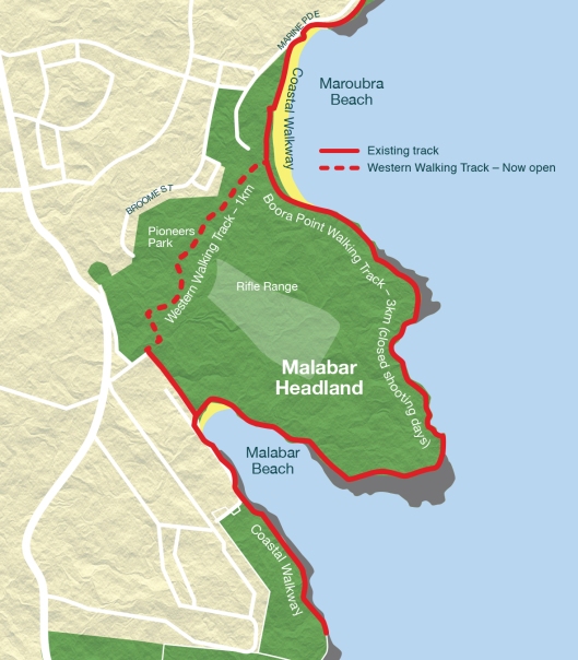
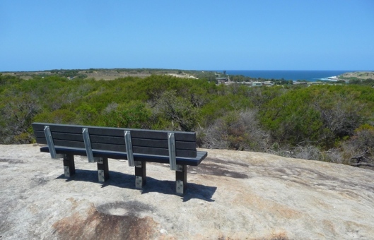
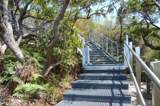
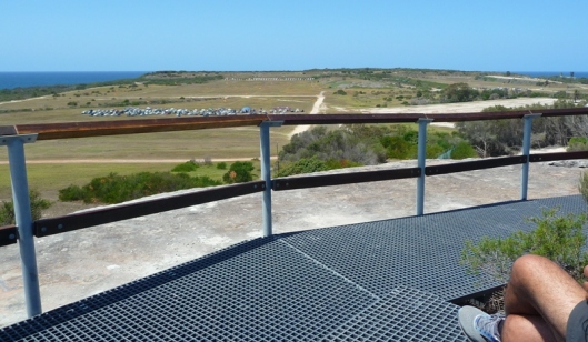
The 1.15 km walkway forms a missing link in the coastal walk which can be used instead of the of the longer 4km coastal track from South Maroubra to Malabar (Long Bay) which is closed to the public when the rifle range is in use on Saturdays, third Sunday of each month, and various weekdays. The walkway, largely a grid-style boardwalk, makes a path up and down through remarkably lovely coastal heath and woodland. The high part on the escarpment overlooks the rifle range for a splendid view of the ocean.
FoMH will continue to work to help the community to meet the challenge of caring for high quality bush so close to suburbia. The park survived informal use over many years. Ongoing problems include littering, dumping, campfires, dogs, and tramping off the tracks. We hope that with increased formal use and popularity, everyone will act in a friendly manner towards Malabar Headland.


References:
http://www.yoursayrandwick.com.au/malabarwalkway viewed 13 February 2018
https://www.randwick.nsw.gov.au/planning-and-building/council-works-and-upgrades/major-projects/coastal-walkway-works viewed 13 February 2018
https://malabarheadland.org.au/
http://leptracking.planning.nsw.gov.au/proposaldetails.php?rid=406
http://www.environment.nsw.gov.au/resources/threatenedspecies/determinations/FDESBSCEEC.pdf
https://www.nationalparks.nsw.gov.au/visit-a-park/parks/malabar-headland-national-park/local-alerts
Photos supplied by Claire Bettington, FoMH
Map supplied by Randwick Council.

Thanks for the update. I suppose we must be grateful that we can use the proper coastal walk on a few Sundays each month- shame for those who have to work Saturdays and during the week of course which is the case with me. Just not the same being stuck up a long way from the glorious views available on the proper coastal walk so we walk from the pistol range to Bare Island now on Saturdays although I think you can still sneak around the coastal walk before 6.30am.
Appreciate all you are doing though to keep it in good shape.
Regards
Terry
It is a great Park the trouble is I arranged a walk with some friends last Sunday the 1st July to find the park closed again. I thought the park was closed on the third Sunday of each month but the guards informed me it was a training day and therefore closed, many other people were being turned away.
Looks like the Rifle Range can do whatever they want?